I recently headed over to France for another weekend cycling trip. This time I stayed the night in Oostende, Belgium, so that I could cover more distance in the trip on the continent. This time I headed over using SeaFrance instead of P&O since they were significantly cheaper when returning the following day, rather than the same day. I took a coastal route heading out, and a more inland route on the way back for some variety.
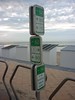
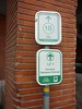
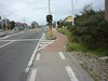
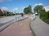
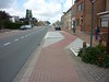
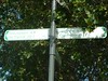
I found it interesting to use many of the Belgian cycling facilities, including the cycle node networks and the cycle paths. The cycle node networks are quite different to the UK cycle network routes. Rather than having a route that often runs a long distance, you have fairly short distance routes between numbered points. Between the points you get signs directing you to another point. When you look behind, you’ll see directions to the point that you have just come from. This seems to work better in town/built-up areas, as it gives more of a mesh network, rather than a spoke network that the route network in the UK tends to promote.
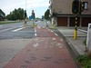
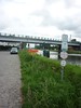
It was really nice to see cycle lanes nicely run on to the pavement as a cycle path; or priority over other junctions; or being routed behind bus stops, so that cyclists don’t need to swerve out and merge with the rest of the traffic when buses stop.
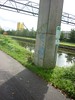
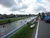
When I was cycling along the LF1 beside a canal, I seen people playing some form of volleyball in canoes on the canal.
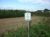
Just as I was about to leave the last town in Belgium on the way back to Calais, I was flagged down by a group of 3 students who were looking for directions to get on to the North Sea Cycle Route. Having seen 2 or 3 signs for the route, I was able to give them some pointers about cycling in Belgium, as it is a bit different to the UK, and point them in the right direction. They did have maps based on car-centric Google maps showing the route and were thinking about riding on the UK equivalent of trunk or primary roads, however in Belgium (and other European countries), you are often not allowed to cycle on those busy roads, rather you are meant to use the adjacent or nearby cycle paths.
When I was entering the data from my journey, I was chatting on IRC to one of the local OSM mappers, so that I could get a better idea of how the data should be entered. I learned that the North Sea Cycle Route is actually signed on the ground as LF1, though there does appear to be a coastal and inland strand of it. I am still a little confused by it being signed as LF1 in some places and having North Sea Cycle Route signs in other places, and nothing linking the two on the ground.
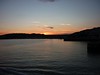 While waiting for the ferry in Calais I had a nice chat with one of the motorcyclists and car ferry passenger. On the ferry over I had my dinner. I had pre-paid for it as you get 10% off the cost of the meal deal. On arriving in Dover there was a nice sunset over the harbour.
Overall it was a total of 140 miles over two days, 125 miles of which was on the continent. I’ve uploaded the photos from my trip to Flickr.
[osm_map lat=”51.068″ long=”2.38″ zoom=”9″ width=”500″ height=”450″ gpx_file=”/wp-content/uploads/gpx/calais-oostende-simplified-2000.txt.gpx”]
Little hint: The game on the canal is called “canoe polo” 🙂 Some people seem to tag it in OSM as well: http://wiki.openstreetmap.org/wiki/Proposed_features/Canoe