Last Sunday (30/8/09) Simon Hewison and myself took the first train from London Paddington to Bristol at the fairly early time of 8am considering that we had to cycle across London first. We had purchased advanced fare tickets which were about a third of the price of the walk up fares.
Total distance for the main part of the route was about 80 miles. I also cycled just over 10 miles in each direction to and from London Paddington. I was originally planning to continue into the M25 and get a train from there or even continue through the night home. However the weather was very overcast and damp, and we were covering a greater distance than originally anticipated due to taking a bendy route and sometimes missing the directions signs for the National Cycle Network Route 4 and having to backtrack. We avoided mapping so that we could get a much greater distance. There were some roads that weren’t in OSM, and we found that the NCN 4 had been re-routed with part of the original route being renumbered.
Here’s some photos of the day:
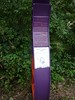 This appears to be a variant of the Sustrans signposts, specific to the Bristol – Bath cyclepath on an old railway line.
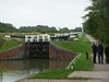 Here was the big staircase of locks that we cycled past.
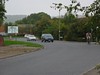 Having the current OSM data on my phone means that I made Simon rather curious as to what the junction at the end of the road was. There was a sign stating that there was a roundabout, however there was just a simple T-junction in OSM. He raced off and caught a trace. I had been taking various photos of other little bits of data to add to OSM.
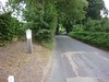 There were several roads that we went along where there were signs that stated you were on a “quiet lane”. Do these have any special status?
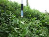
There was a bit of a problem of knowing the way at this junction until Simon beat the foliage down so that the ncn4 direction sign was visible.
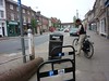 When we arrived in the aptly named Hungerford, it was time for dinner so we found a hotel restaurant and collected the postcode and a couple of other POIs in passing, such as the bike parking in the centre of the village.
Quiet Lanes are a DfT/Countryside Agency initiative that a few counties have tried – I’ve seen them in the Chilterns, for example. More details at http://www.dft.gov.uk/pgr/roads/tpm/tal/trafficmanagement/quietlanesa . Definitely worth tagging expressly (maybe with the designation= tag?).
I think I tagged one of them as lane=quiet.